Showing posts with label Landscapes. Show all posts
Showing posts with label Landscapes. Show all posts
Thursday, October 04, 2012
Friday, February 17, 2012
New frontiers in long-distance hiking: a proposed Great Plains Trail. Pretty neat idea, though I imagine securing access and easements would be a long, long process. But I'd certainly check out the New Mexico sections if it ever comes about.
Saturday, April 18, 2009
Apologies for the month of silence. But you haven't missed much, readers. A promising storm system in early March took me on a photo expedition to the great Socorro/Catron County outback of western New Mexico. Here's dawn from Hell's Mesa, some 20 miles north of Magdalena:
It's a bit of a New Mexico cliche, but who can pass up the VLA in good light?


The photo is quite dated now, but again, who can pass up tazi puppies?

Our big excitement was when Mr. and Mrs. Odious returned to New Mexico for the first time in several years. An excellent time was had by all, and Odious was given an airing in a landscape as little like western Oregon as possible:

We also had a very good visit to Dallas, of all places, for Mrs. P's sister's wedding. Bonuses included a very good time staying with Proclus (who really ought to blog a little now that he has some spare time) and his delightful new dog, an afghan/poodle cross, a mix we feel certainly qualifies as a lurcher; much good food; camels and bluebonnets on the drive; and a visit to the excellent if overpriced King Tut exhibition.
With any luck at all, we'll become interesting again soon.
Sunday, September 14, 2008
If you're among our northern New Mexico readers and enjoy landscape art, you really ought to stop by the Gerald Peters gallery in Santa Fe and check out the exhibition of Tony Foster paintings. I'm generally a bit lukewarm on most landscape painting, but Foster's stuff gives me the same "I've got to go there" emotional response I normally seek in photographs. He paints on location, often at very obscure and remote locations indeed, sometimes working for a week on a six-foot piece at 15,000 feet and that sort of thing. I love his use of white space, especially in his Himalayan work. And there are some nuances that you can only see in the original, such as a Himalayan snowstorm painting where he actually scraped streaks across the finished work to achieve the effect of a violent flurry.
He's also done a lot of painting in central Idaho, particularly on the Salmon, which made it pretty much inevitable that I own his book (thanks to Mrs. P's sweetness and generosity).
Definitely worth a stop if you're in town. Runs through November 15.
Thursday, February 28, 2008
Images and video of the moon's south polar region:
“We now know the south pole has peaks as high as Mount McKinley and crater floors four times deeper than the Grand Canyon,” said Doug Cooke, a deputy associate administrator at NASA.Have I mentioned that I'm all for terraforming other worlds? Particularly worlds with abundant rafting and mountaineering potential.

Friday, February 01, 2008
Meanwhile, back at Diablo Canyon....
We saw 3:10 to Yuma recently the recent remake, not the original), and I was highly pleased. It really is nice to see a well plotted, well acted (Russell Crowe is great, but I kept thinking, "How did Jack Aubrey become an old west outlaw?"), generally quality western, and looking at some home landscapes in cinematic context was an added treat. For instance, here we have the distinctive profile of Buckman Mesa beside Christian Bale's boot:

And here's Peter Fonda about to flip a stage coach in my old haunt of Diablo Canyon:

I actually wandered out there inadvertantly during filming to take a hike, and saw a flock of trailers and signs pointing toward various chase sequences. Through a remarkable act of willpower, I resisted the urge to climb the back of the mesa and trundle some rocks on the invaders, whoever they might be. In hindsight I regret it; I might have serendipitously contributed to a fine film. As I recall, they did manage to kill a horse with no help from me. What's a western movie without at least one dead horse?
On the other hand, what's with Hollywood's inveterate, unyeilding dyslexia in regard to landscapes? Yes, yes, it doesn't bother most audiences, nor should it really, but just once I'd like to see them get one right. 3:10 to Yuma is set in Arizona, but was obviously filmed entirely within about 30 miles of Santa Fe. Unbelievable as it may seem to the masses, most of New Mexico (particularly Santa Fe) looks nothing like most of Arizona (particularly Bisbee). Just once, just once I'd like to see a western in which landscape nerds like me could turn to our dates with a satisfied snigger and say (for instance), "See, Captain Gunnison's not being shot full of Paiute arrows just anywhere. That really is the Sevier Desert!" "Fremont's men are eating each other in the real La Garitas!" How cool would that be? Seems like we're about due for a new Apache movie, and wouldn't it be wonderful to see one filmed in vast, intricate, utterly bizarre landscapes of southern Arizona and southwestern New Mexico instead of the done-to-death vistas of Monument Valley and southern Utah?
Sigh. No one likes my ideas. I spent half the afternoon imagining a western with a plot based on Njal's Saga.
Monday, December 31, 2007
Year's End Outing with Rock Art
Here are some scenes of my last hike of the year, yesterday, in a very fine, moderately isolated canyon in western Colorado (the diligent can surely deduce the location, but my current stance is that nowhere needs any publicity whatsoever). First, the context, with frozen waterfall. The bedrock is basement metamorphic schist, overlaid by some odd red granitish stuff I couldn't place, followed by cliff-forming Wingate sandstone:

Unsurprisingly, the Indians liked this place. Inhabitants included Desert Archaic culture, possibly the Fremont and certainly historic Ute. One sees hand prints pretty often, but I was pleased to find one that strikes me as a bear print:

Some abstracts, in their spectacular gallery:

The same up close:

Historic Ute presence is clearly visible here. I hesitate to identify the beastie. The first thing that leapt to my mind, somehow, was horny toad, but it seems hard to justify any taxon with close examination:

An elegant pecked herbivore body, reminds me of the graceful forms of Old World rock art:

Another panel in splendid context:

Detail of above. Again, hand prints are common enough, but the unusual inclusion of the arm here conveys a reaching, grasping which is highly evocative. Though hardly objectivly warranted, thoughts come to the mind of desparation, clutching at the stone:

Finally, what can this engraving evoke save hunting magic? The bighorn sheep, perched in a high place, surveying the territory; likewise the artist/hunter, eulogizing his prey in stone as he too scans the canyon for another animal.

And so the author, high against the cliff, crouching and looking at the canyon, red stone, frozen stream, the tribes gone, the sheep still here.
Long time gone.
Friday, June 29, 2007
...Nessun maggior dolore
che ricordarsi del tempo felice
ne la Missouria...
che ricordarsi del tempo felice
ne la Missouria...
Apologies. But 'twas apt: I recently journeyed from this:
to this:


Fortunately, I also returned again, sorry though I was to travel home without a single Dolly Parton lollypop, which I initially took for a succubus with burning eyes and bleeding nipples. Many other marvels and wonders also remain unvisited. Very sad indeed were we to decline a kind Ozark invitation to light our fireworks at a big cat refuge on the Fourth, surely an ideal venue for pyrotechnic revelry.
We did however enjoy some truly excellent tapas in Dallas, and had a delightful stay with Reid, who assures me that there are some really wonderful river floats to be had in Missouri. And the flight from the midwest to Denver was oddly delightful. One passes dreamlike over the clutching effusion of greenery that is east Texas, through a Euclidean hallucination of square acreages and trigonometric circle-pivot fields, into the dendritic fractal landscape of eastern Colorado's slowly eroding plains, at last reaching the Wagnerian welcome of the Rockies.
In Montana at the moment, and off to Oregon and Odious tomorrow, on the wings of newly-installed used radiator (Mrs. Peculiar's birthday present). Blogging next from there, in the best of company.
Saturday, February 17, 2007
More photoblogging
Some shots from last night in our local mountains, the southern end of the Sangre de Cristo range:


This is one of New Mexico's largest aspen groves, if not the largest. A number of people have pointed out articles such as this, about spreading malaise among the aspen groves of the west. No one knows quite what's going on, but drought and fire supression seem the most reasonable explanations to me. In any case, the southern and central Rockies remain full of spectacular groves, and the prospect of an aspen holocaust is not making me lose any sleep at night.


Tuesday, January 10, 2006
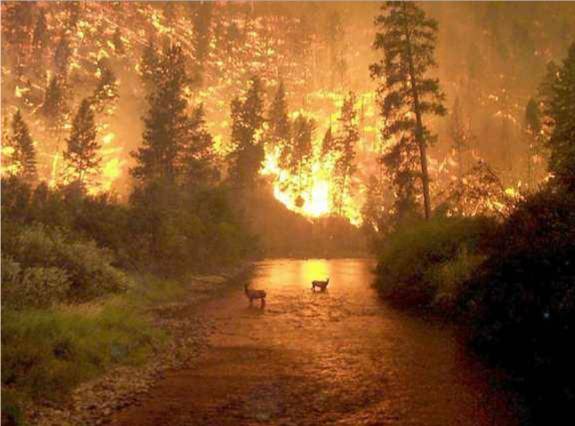
I recently stumbled across the above photograph, an image I remember well (not exactly fondly) from five-and-a-half years ago. It's a picture of the 2000 fires in the Bitterroot Valley, specifically the East Fork of the Bitterroot outside Conner, Montana. I was quite nearby at the time, in Salmon, Idaho, about an hour's drive south. It was the first time I was in the vicinity of major forest fires. I remember the smoke clouds to the west being so thick that we could look directly at the sun, sometimes seeing sunspots with our naked eyes through the perfect brown filter.
I've since floated and driven through several other small to medium fires. Though I was never in a scene as hellish as that photo, active blazes do put one in mind of scenes a few circles down in Inferno. The light is veiled and ruddy, the air unwholesome. Blackened silhouettes of trunks and stumps stand naked, carved into Rococo shapes by burning, some smoking like chimneys. Smoke pours from holes in the earth and stones tumble down the loosened slopes. Flames ripple up brushy hillsides or crackle into crowns of trees. I floated through one such on the Main Salmon in 2003 without incident. It seemed that we had come through after the worst was over, as the fire was calming down. But the next morning we awoke to strong winds, and looked back upstream to see an immense column of yellow-orange erupting into the sky above the canyon.
Whenever I have seen such fires in action, I have assumed the worst about what would be left when the flames were gone. But every time I have been pleasantly surprised. Where there's smoke there's fire, but there's usually vastly more smoke. The areas you see marked as burned in newspaper maps are very far from wastelands. Some patches are indeed devastated, but most areas are only mildly singed. Undergrowth soon flourishes happily, and wildflowers are profuse in the following years. Wildlife doesn't seem to mind burned zones particularly. I even spent time in the Kalmiopsis Wilderness in the years immediately following the Biscuit Fire, possibly the nastiest burn in living memory. Even there, there are still living trees, limpid water, bears, salmon, carnivorous plants. The most dramatic aftereffects (in Idaho, at least) are landslides. The rivers have run clear much more seldom than they did before the fire years, as any reasonably focused downpour induces the loosened mountainsides to cast themselves down in a wall of mud, logs and stones, often giving the rivers some wonderful new rapids in the process.
 Cramer Creek Rapid (a.k.a. De-Rig) formed overnight from a debris flow in August 2003, shortly after the Cramer Fire, creating some of the biggest whitewater on the Salmon.
My point in all this is that forest fires most definitely do not destroy an area's value as wilderness. Nature's change and growth is often not a gentle process; there is violence and destruction in it. That is where much of the awe and majesty of wilderness is to be found, and it is what sets true wilderness apart from gentlemen's estates. The notion implicit in salvage logging of burned forests is that the area is ruined, so why not pull what resources we can from it? I don't mind the resource extraction per se. What I greatly mind is the attendant road-building in roadless areas, excused on the grounds of this alleged ruination, which is believable only to those who have no serious knowledge of the areas. Wilderness should be managed as wilderness, through fires, floods and everything else. I say again, these areas are far from ruined, even on the scale of a few years. Seeing them change, through slow growth or sudden shock, in ways one would never guess, is one of the great delights and privileges of knowing the wilderness.
This is sadly likely to be an issue in my neck of the woods in the coming year. New Mexico has had no significant snowfall this season; our 12,000-foot mountains show no white at all. There have already been fires in Colorado: it's freakin' January! For all I've said above, please don't think I enjoy seeing forests burn. I definitely don't want to see the entire Pecos Wilderness burn in a week. If we don't get some precipitation soon, things will be very grim. But they'll still be better than an infestation of new roads.
Tuesday, June 10, 2003
At last, as promised: The Illinois River
As you faithful readers may have deduced, I spend my summers in the employ of a whitewater rafting company. We have operations in four western states, and thus I am fortunate enough to have boated many of the finest wilderness rivers in the country. This April I managed to see one of the crown jewels of them all; I’ve run the Grand Canyon, the Yampa, the Middle Salmon and the Selway, and the Illinois in southwestern Oregon is the equal of any of them.
There’s a reason you’ve never heard of the Illinois: it’s very difficult to catch it at runnable water levels. Unlike most commonly rafted rivers, it is fed not by snowmelt or reservoir, but by rain. It therefore can be boated only in winter and spring, and even then the levels are touchy. A few dry days can leave insufficient water to squeeze a raft between the boulders, and a decent storm system can transform its already challenging whitewater into screaming insanity. Below 800 cubic feet per second or above 3000 we don’t go; and it’s the only river I’ve ever run where one worries about its being too high and too low in the same week. I drove from New Mexico to southwestern Oregon well aware that scheduled trips often never launch.
Preparing to launch on a new river is always an exciting experience, and this time I had numerous factors contributing to my excitement. The weather in Grant’s Pass was cold and rainy, and our guidehouse did not yet have a water heater up and running. I was quite aware that certain Illinois rapids would be a step up in difficulty from anything I had ever rowed. And we were constantly thinking about the water level, trying to guess just how the storm drumming on our roof was affecting a river valley thirty miles to the south. A Coast Guard weather radio on our kitchen table gave comment in a slate-gray automated baritone: "forecast for western Josephine county is… rain… eastern Curry county… rain… fifteen foot swells in Brookings harbour…." Throughout the day, periodic internet flow updates came via our manager’s girlfriend in Eugene. At eight in the evening she reported a spike from 1300 cfs to 2400, which certainly grabbed our attention; it was a joke, but hardly an outrageous or unbelievable one, as events three days later would demonstrate. I fell asleep to thoughts of whitewater and the sounds of the wood stove and the raindrops.
It was still raining in the morning as we drove south to Selma in the Illinois valley, then west on dirt roads into the river canyon, where the Illinois slices through the coast range on its way to the Rogue and the Pacific. To run the Illinois is legally easy; there is no decades long Grand Canyon waiting list, no Selway permit lottery with astronomically poor odds. All you have to do is drop a form in a box on the side of the Selma grocery store and go. But the difficulty of the rapids and the inconvenience of transporting river gear long distances to a river which may well not be boatable in any given week tend to keep the crowds away. The locals seem to derive a good deal of their winter and spring entertainment from news of Coast Guard rescues of incompetent or unlucky rafters, and hence few of them run the river. We launched our boats in splendid isolation, in which we remained for the entire trip.
For one like me who delights in moving water in all its manifestations, the Illinois canyon is a paradise. Almost the first thing one sees after pushing off from shore are waterfalls, a side stream plunging in two branches into the bedrock gorge. There are waterfalls throughout the canyon, around almost every bend, sometimes four or five in a mile, of all sizes, heights and steepnesses, sometimes two or three together. The raindrops bead up and roll like quicksilver on the river’s surface, and when the sun appears the river water blooms a transparent, luminous emerald. The rapids for the most part are friendlier than I had anticipated; from the sheer quantity of rapids in the guidebook (well over one hundred in forty miles) I was expecting the continuous whitewater of the Selway or upper Middle Fork, where rapids flow straight into one another and one is constantly rowing. But these had (at 1300 cfs at least) good recovery pools in between. The most common anatomy was a tight but slow-moving rock garden feeding into a pushy, splashy bedrock chute full of waves and medium-sized pour-overs. Many of the more difficult rapids call for a tricky, twisty set-up, one last push, then shipping your oars for a drop into a steep slot between boulder and cliff, barely wider than your boat. The side streams are gin clear or pale, almost glacial blue, and they and the river sculpt themselves into gravity-defying slopes and fins and rooster-tails, smooth and clear as glass, stationary forms in flowing water.
Though it is not far as the crow flies from roads and towns, the Illinois feels remote and isolated like nowhere else I have ever been. Even the Selway, so rightly renowned for its remoteness and isolation, has trails and pack bridges and airstrips, but the Illinois has none of these. It flows through the northern end of the Kalmiopsis Wilderness, and the Tututni Indians and miners who once lived here are long gone. There are some trails marked on the USGS maps, but when you go to look for them you find nothing but eroding dirt and poison oak. It is country which inclines one to believe in sasquatches. The botanical diversity is the best in the west, with dozens of conifers and broad-leaved species, rare purple kalmiopsis flowers, and carnivorous California pitcher plants raising their green cobra hoods at the water’s edge. Our second night campsite was covered with the droppings of Roosevelt elk, and nearby we found a salmon skeleton which certainly did not get so far from the river on its own.
Even after launch the Illinois calls for flexibility in scheduling. We always bring food for an extra day, canned beans and powdered soup and the like, so that if the water should rise suddenly we can wait it out. On our standard four day schedule, we plan for a short second day on the river with lots of hiking, and a long, difficult third day through the biggest rapids in the gorge section. But the Coast Guard radio was out again on our first night and second morning, in case a forecast of heavy rain should dictate a long dash the second day all the way through the gorge and past the most dangerous whitewater.
As it happens, we stick to our ideal schedule, with a beautiful sunny hike the second day, through a pit of sunbathing snakes, wading up a creek, and climbing a ridge to a cliff overlooking a Peregrine nest. The third day is full of hard rain without a break. The rapids are challenging, but again mostly easier and more fun than I had expected. The exception is the Greenwall. It’s quite fortunate that the Greenwall is there, since without it the Illinois would probably see much more traffic than it does; but during our scout I find myself distinctly desiring it to be gone. The left side of the river laps against and sometimes flows through a vast array of enormous boulders; the right side races along a towering cliff covered in green moss. The top half of the rapid is not terribly difficult, but complicated enough to clutter the memory and full of plenty of hydraulics big enough to interfere with a boatman’s plans. The bottom half flows very fast through several holes and waves big enough to flip a sideways boat, and with the dangerous undercut wall always threatening on the right. And between the two halves is a pounding ten foot fall between boulders. The entire thing looks very unpleasant to swim. My anxiety is not helped by the knowledge that I will be the first boat through; even though I have never run this rapid, I am carrying no clients, and the other guides hope to have me waiting at the bottom to rescue any of their passengers who might swim. My run is neither very good nor very bad, but the other guides learn from watching me and their runs are clean.
We continue downriver through splendid, less nerve-wracking whitewater. The rain persists into the evening, and by the time we finish setting up camp there is a waterfall coming off the rocks behind our kitchen which was not there when we arrived. The river is changing colour and growing cloudier, and is clearly on the rise. After dinner, we put up an extra rope to the boats and move our gear uphill. I fall asleep listening to the basso ostinato of the nearby rapid, the soprano clatter of the growing waterfall, the alto murmur of the raindrops on our kitchen tarp.
Our head guide joins me under the tarp a little past midnight, reporting that there is now current through his tent site, which was by no means foolishly close to the water when he went to bed. In the morning our boats, which we left with their noses pulled up on the sand, are now thoroughly afloat in two feet of water. We have to swim to retrieve an overlooked box lid, and must scramble over the rocks to reach our toilet, the trail to which is now well in the current. The rapid has completely changed character, its formerly exposed rocks deep underwater forming some impressive standing waves. We ride to take-out on what we later learn is well over double the volume of the previous day’s water*, making the manager’s girlfriend’s joke seem feeble in comparison.
So that’s the report from my world. I’m currently guiding on the Yampa, and I’ll be heading to Idaho shortly. I’ll try to get a post out occasionally, but don’t expect much; time and internet access are not abundant resources for me right now. Cheers to our loyal readers, welcome to any new ones, and if Odious would be so good as to copy this post to our archives, I would appreciate it.
*The spike was from 1300 to 3400 cfs on the gage upstream at Kerby; actual flows in the canyon, below so many side streams, are substantially greater.
As you faithful readers may have deduced, I spend my summers in the employ of a whitewater rafting company. We have operations in four western states, and thus I am fortunate enough to have boated many of the finest wilderness rivers in the country. This April I managed to see one of the crown jewels of them all; I’ve run the Grand Canyon, the Yampa, the Middle Salmon and the Selway, and the Illinois in southwestern Oregon is the equal of any of them.
There’s a reason you’ve never heard of the Illinois: it’s very difficult to catch it at runnable water levels. Unlike most commonly rafted rivers, it is fed not by snowmelt or reservoir, but by rain. It therefore can be boated only in winter and spring, and even then the levels are touchy. A few dry days can leave insufficient water to squeeze a raft between the boulders, and a decent storm system can transform its already challenging whitewater into screaming insanity. Below 800 cubic feet per second or above 3000 we don’t go; and it’s the only river I’ve ever run where one worries about its being too high and too low in the same week. I drove from New Mexico to southwestern Oregon well aware that scheduled trips often never launch.
Preparing to launch on a new river is always an exciting experience, and this time I had numerous factors contributing to my excitement. The weather in Grant’s Pass was cold and rainy, and our guidehouse did not yet have a water heater up and running. I was quite aware that certain Illinois rapids would be a step up in difficulty from anything I had ever rowed. And we were constantly thinking about the water level, trying to guess just how the storm drumming on our roof was affecting a river valley thirty miles to the south. A Coast Guard weather radio on our kitchen table gave comment in a slate-gray automated baritone: "forecast for western Josephine county is… rain… eastern Curry county… rain… fifteen foot swells in Brookings harbour…." Throughout the day, periodic internet flow updates came via our manager’s girlfriend in Eugene. At eight in the evening she reported a spike from 1300 cfs to 2400, which certainly grabbed our attention; it was a joke, but hardly an outrageous or unbelievable one, as events three days later would demonstrate. I fell asleep to thoughts of whitewater and the sounds of the wood stove and the raindrops.
It was still raining in the morning as we drove south to Selma in the Illinois valley, then west on dirt roads into the river canyon, where the Illinois slices through the coast range on its way to the Rogue and the Pacific. To run the Illinois is legally easy; there is no decades long Grand Canyon waiting list, no Selway permit lottery with astronomically poor odds. All you have to do is drop a form in a box on the side of the Selma grocery store and go. But the difficulty of the rapids and the inconvenience of transporting river gear long distances to a river which may well not be boatable in any given week tend to keep the crowds away. The locals seem to derive a good deal of their winter and spring entertainment from news of Coast Guard rescues of incompetent or unlucky rafters, and hence few of them run the river. We launched our boats in splendid isolation, in which we remained for the entire trip.
For one like me who delights in moving water in all its manifestations, the Illinois canyon is a paradise. Almost the first thing one sees after pushing off from shore are waterfalls, a side stream plunging in two branches into the bedrock gorge. There are waterfalls throughout the canyon, around almost every bend, sometimes four or five in a mile, of all sizes, heights and steepnesses, sometimes two or three together. The raindrops bead up and roll like quicksilver on the river’s surface, and when the sun appears the river water blooms a transparent, luminous emerald. The rapids for the most part are friendlier than I had anticipated; from the sheer quantity of rapids in the guidebook (well over one hundred in forty miles) I was expecting the continuous whitewater of the Selway or upper Middle Fork, where rapids flow straight into one another and one is constantly rowing. But these had (at 1300 cfs at least) good recovery pools in between. The most common anatomy was a tight but slow-moving rock garden feeding into a pushy, splashy bedrock chute full of waves and medium-sized pour-overs. Many of the more difficult rapids call for a tricky, twisty set-up, one last push, then shipping your oars for a drop into a steep slot between boulder and cliff, barely wider than your boat. The side streams are gin clear or pale, almost glacial blue, and they and the river sculpt themselves into gravity-defying slopes and fins and rooster-tails, smooth and clear as glass, stationary forms in flowing water.
Though it is not far as the crow flies from roads and towns, the Illinois feels remote and isolated like nowhere else I have ever been. Even the Selway, so rightly renowned for its remoteness and isolation, has trails and pack bridges and airstrips, but the Illinois has none of these. It flows through the northern end of the Kalmiopsis Wilderness, and the Tututni Indians and miners who once lived here are long gone. There are some trails marked on the USGS maps, but when you go to look for them you find nothing but eroding dirt and poison oak. It is country which inclines one to believe in sasquatches. The botanical diversity is the best in the west, with dozens of conifers and broad-leaved species, rare purple kalmiopsis flowers, and carnivorous California pitcher plants raising their green cobra hoods at the water’s edge. Our second night campsite was covered with the droppings of Roosevelt elk, and nearby we found a salmon skeleton which certainly did not get so far from the river on its own.
Even after launch the Illinois calls for flexibility in scheduling. We always bring food for an extra day, canned beans and powdered soup and the like, so that if the water should rise suddenly we can wait it out. On our standard four day schedule, we plan for a short second day on the river with lots of hiking, and a long, difficult third day through the biggest rapids in the gorge section. But the Coast Guard radio was out again on our first night and second morning, in case a forecast of heavy rain should dictate a long dash the second day all the way through the gorge and past the most dangerous whitewater.
As it happens, we stick to our ideal schedule, with a beautiful sunny hike the second day, through a pit of sunbathing snakes, wading up a creek, and climbing a ridge to a cliff overlooking a Peregrine nest. The third day is full of hard rain without a break. The rapids are challenging, but again mostly easier and more fun than I had expected. The exception is the Greenwall. It’s quite fortunate that the Greenwall is there, since without it the Illinois would probably see much more traffic than it does; but during our scout I find myself distinctly desiring it to be gone. The left side of the river laps against and sometimes flows through a vast array of enormous boulders; the right side races along a towering cliff covered in green moss. The top half of the rapid is not terribly difficult, but complicated enough to clutter the memory and full of plenty of hydraulics big enough to interfere with a boatman’s plans. The bottom half flows very fast through several holes and waves big enough to flip a sideways boat, and with the dangerous undercut wall always threatening on the right. And between the two halves is a pounding ten foot fall between boulders. The entire thing looks very unpleasant to swim. My anxiety is not helped by the knowledge that I will be the first boat through; even though I have never run this rapid, I am carrying no clients, and the other guides hope to have me waiting at the bottom to rescue any of their passengers who might swim. My run is neither very good nor very bad, but the other guides learn from watching me and their runs are clean.
We continue downriver through splendid, less nerve-wracking whitewater. The rain persists into the evening, and by the time we finish setting up camp there is a waterfall coming off the rocks behind our kitchen which was not there when we arrived. The river is changing colour and growing cloudier, and is clearly on the rise. After dinner, we put up an extra rope to the boats and move our gear uphill. I fall asleep listening to the basso ostinato of the nearby rapid, the soprano clatter of the growing waterfall, the alto murmur of the raindrops on our kitchen tarp.
Our head guide joins me under the tarp a little past midnight, reporting that there is now current through his tent site, which was by no means foolishly close to the water when he went to bed. In the morning our boats, which we left with their noses pulled up on the sand, are now thoroughly afloat in two feet of water. We have to swim to retrieve an overlooked box lid, and must scramble over the rocks to reach our toilet, the trail to which is now well in the current. The rapid has completely changed character, its formerly exposed rocks deep underwater forming some impressive standing waves. We ride to take-out on what we later learn is well over double the volume of the previous day’s water*, making the manager’s girlfriend’s joke seem feeble in comparison.
So that’s the report from my world. I’m currently guiding on the Yampa, and I’ll be heading to Idaho shortly. I’ll try to get a post out occasionally, but don’t expect much; time and internet access are not abundant resources for me right now. Cheers to our loyal readers, welcome to any new ones, and if Odious would be so good as to copy this post to our archives, I would appreciate it.
*The spike was from 1300 to 3400 cfs on the gage upstream at Kerby; actual flows in the canyon, below so many side streams, are substantially greater.
Subscribe to:
Posts (Atom)