Showing posts with label geomorphology. Show all posts

Tuesday, June 24, 2025

 The 23,000 year chronology for those footprints at White Sands seems to be holding up to confirmation.

This paper reports on an independent study of the chronology of a previously unrecognized stratigraphic record of paleolake Otero that is directly traceable into the track-bearing alluvium. The stratigraphic data along with 26 additional radiocarbon dates on palustrine mud determined by two labs independent of the original investigations document an aggrading lake/wetland/stream record that includes the tracks and spans >23.6 thousand years to ~17.0 thousand calibrated years before present, providing another line of evidence further supporting the validity of an LGM age for the tracks. 

Sunday, February 10, 2013

Friday, April 15, 2011

The tallest known cliff in the solar system: Verona Rupes on Miranda, 12 miles high. For comparison, El Capitan in Yosemite is about 0.6 miles high.

And here's a 2.5-mile high cliff band on Mars. Terraforming, please!

Wednesday, March 30, 2011

Massive new arch discovered in Afghanistan, one of 14 natural spans in the world over 200 feet. Very cool, even if it does bump Dinosaur National Monument's Outlaw Arch a notch down the list. Complete list of 200'+ arches here.

Friday, January 28, 2011

Some Himalayan glaciers may be expanding rather than shrinking:
[The] report, published in the journal Nature Geoscience, found the key factor affecting their advance or retreat is the amount of debris – rocks and mud – strewn on their surface, not the general nature of climate change.

Glaciers surrounded by high mountains and covered with more than two centimetres of debris are protected from melting.

Debris-covered glaciers are common in the rugged central Himalaya, but they are almost absent in subdued landscapes on the Tibetan Plateau, where retreat rates are higher.

In contrast, more than 50 per cent of observed glaciers in the Karakoram region in the northwestern Himalaya are advancing or stable.
These observations regarding debris bring to mind the reported construction of artificial glaciers by Balti villagers in times past:
The last glacier to be started, we were told, had been made 35 years earlier by the grandfather of the present rajah. It had been built to an ancient formula, with ice blocks coming from male and female glaciers (their difference was not made clear). These blocks were deposited in a high valley and covered with charcoal and thorn bushes, on top of which 50 goatskins of water were placed. The water was to help keep the ice cool and to augment the ice supply when the water froze in winter. After 20 years of gradually adding ice and snow, the glacier became strong enough to support itself and send a constant supply of water in the nonwinter months to the dry fields below.

Thursday, August 28, 2008

Lake Mead: Silt, Superposition & Whitewater

One of the most interesting parts of my recent Grand Canyon trip was floating past the usual takeout at Diamond Creek and continuing all the way to Lake Mead. I'd never seen this lower stretch before, and it was certainly very beautiful and pretty fascinating. I do not, however, recommend it in August: our daily highs were somewhere in the neighbourhood of 115 F.

The water level in Lake Mead is currently very, very low. Note the bathtub ring in the photo to the left (click photos for larger, better versions). This was well out within the theoretical perimiter of the so-called lake, and the ring represents the old average pool. This location is also at least 20 miles dowstream of where my map informed me was current's end at the Lake's historic low. Clearly, we've been breaking records for years and years! To add to the general amusement of the place, there were feral bulls wandering about on the river bank.


Unsurprisingly, the name of the game in the Lake is silt. At the Lake's historic high backwater, still well within the Grand Canyon proper, we began seeing banks of silt covering the river's true banks, and as we continued downstream they grew higher and more extensive. Not infrequently, a section would collapse in our view, avalanching dirt into the river and kicking up prodigious clouds of dust.


Once you come out of the Canyon into the flats, the silt really spreads out, into a vast plain covered in tamarisk and willow, corresponding of course to the shape of the former reservoir. The old takeout at Lake Mead was Pierce Ferry; the Pierce Ferry boat ramp is now over two miles from the river. Thankfully, things are livened up around here by a new rapid which has been forming and changing frequently for the past couple seasons. In addition to providing amusement, the Pierce Ferry rapid also provides a near perfect, small-scale illustration of the principle of canyon cutting by superposition (for a full account, read about the formation of Lodore Canyon here).


What's going on here is that, as the Lake level has dropped, the river was not left with its former basin, but rather with the new expanse of flat silt. Unconstrained by its old banks, which are now deep beneath dirt somewhere, the Colorado could meander over the plain rather freely. In many areas, the river of 2008 is far from its old channel. Of course, the current quickly began cutting down and eroding its silty bed, thus fixing its new course somewhat. But in a couple spots, such as Pierce Ferry Rapid, it hit bedrock outcrops a short ways beneath the surface. In the adjacent photo, the silt plain is clearly visible to the right; the bedrock is forming the boulder in the middle and the pourover and whitewater to the sides where the river flows over it. It's probably being eroded very fast; I'm told the rapid is seldom quite the same from one week to the next. The rapid is also much bigger than it looks in this rather dismal snapshot: for instance, the center boulder is easily 25 feet wide, and the whitewater is plenty capable of flipping a loaded boat.


One of our party running the right channel.


Definitely enlarge this one!


If you imagine a much bigger plain and a lot more bedrock in the picture, it's easy to see how a river becomes entrenched in its own course and incises its meandering path deep into stone.

Also interesting is where the river finally ends. Current's end is not a gradual process at all; it's almost as abrupt as if someone snapped a chalkline across the water. Upstream, the water is brown and cold; five feet downstream, it's green and warm. The silt is still coming, still settling in. You have to see it to appreciate fully the extent of the siltation problems facing Lakes Powell and Mead.

The Colorado comes to a halt.

Monday, July 14, 2008

Major Flash Flooding in Santa Fe!


This was just a couple hours ago, right off the main drag in Santa Fe (St. Francis and E. Alameda, for those keeping score).


You could hear boulders rolling over in the flood and feel the bridge shaking. The SF River was going pretty good, but it was child's play compared to the arroyo (above) draining in from the north, which was easily running 1,000 cfs.


Well, I'm off to run the Grand Canyon for 18 days, and the Colorado won't look much different from the Santa Fe tonight. Hold down the fort, Odious! In the meantime, if you're bored enough, you can entertain yourselves at my photo website. Enjoy!

Sunday, March 09, 2008

The brief Grand Canyon experimental "flood" is over.

I find that perhaps my previous comment on the flood was somewhat unclear. A longtime reader and friend writes:

With the caveat that I am a plant ecologist and not a geohydrologist, and am not familiar with the Salmon River, I think the problem with doing flooding experiments with the Salmon is that there is no dam and thus no large amount of water to use to mimic a flooding event with. Sure, someone could (and I hope is) studying the flood cycle of the Salmon River, but for controlled experiment's sake a damned [sic, indeed] river is better.
(Sorry it's taken me a while to reply, but, well, life gets in the way. And I'm not a geohydrologist either, but I've drunk some beers with them on river trips, so I'll try and do my best to answer.)

The problem with doing flooding experiments in the GC is that there is no large amount of water to use to mimic a flooding event, the dam notwithstanding. Releases from Glen Canyon are determined by a bewildering host of factors: agriculture in California; municipal water needs in Phoenix, Vegas and So-Cal; electricity needs in Arizona; our treaty obligations to provide Mexico with 2 million acre-feet yearly; balancing inflow (i.e., snow melt) with diversions in upper basin states while maintaining useful water levels in three major downstream reservoirs and three major and a host of minor upstream reservoirs. Powell Reservoir has been very low for years now, while water demands continue to increase; no water has reached the Gulf of Mexico since 1982. Under these conditions, sedimentation research in the Grand Canyon is very low on the totem pole.

Indeed, the current flood is really just a small bone thrown to conservationists by the Bureau of Reclamation. Other people besides me are unhappy about the experiment. For instance, the Executive Director of the Grand Canyon Trust:

We need high flows to rebuild habitats whenever we get significant sediment inputs from tributary streams, but instead we get rare, “historic” experiments. We need more natural steady flows through most of the remainder of the year to protect spawning and rearing habitat for humpback chub in the Colorado River, but what we get is continued erosion of backwaters and beaches through an almost unbroken regimen of fluctuating flows... if this high flow experiment is part of a package with no more floods for five years and just two months a year of steady flows, then the package will impair the resources in Grand Canyon.
Or the National Parks Conservation Association:
...the experimental plan fails to include follow-up floods, which are critical to ensuring that endangered fish and sandbars are preserved. Instead, it calls for steady releases during September and October over the next five years –essentially locking-in smaller flows from the dam in order to generate additional power – when larger flows might be more beneficial to the park’s ecosystem at other times of the year, particularly in the spring.
This "flood's" 41,500 cubic feet per second for 60 hours is a paltry flood in a drainage the size of the Colorado Basin. And we only get this every four years (the last such experiment was in 2004). I have no doubt that these events do provide a wealth of data for scientists, and are useful due to their closely controlled nature, one data set in four years is a pretty plodding pace of research.

The big thing that's missing in the science here is baseline data for the behavior of sediment in a natural river system of this size. No one thought to look at any of this before the dam went in in 1963. And there is precisely one river system in the same ballpark in the United States unaffected by dams: the Salmon. Lets look at some hydrographs (which I got here). Here is the Main Salmon's high water season (April-July) for the last two years

2006, a fairly average year:


2007, a low year:


(Note that the scales are not the same; 2007's peak was about 38,000 cfs, while 2006's was over 90,000. That's a ton of water, and the Salmon can go way bigger than that!) Observe how the high flows are spread out over a good three months. Low elevations melt first, it peaks when the weather really heats up, and lingering snow melt and groundwater keep feeding it, stretching out the right end of the graph. Note also the multiple small peaks.

Now lets look at the Colorado. Here's last week, encompassing the flood:


And here's the last 12 months of business as usual at Glen Canyon Dam, with the flood spike at the far right:


In the flood graph, obviously, we have a sharp rise, a steady plateau and a sharp fall, enormously different from a natural high-water episode. In the lower graph, note that the daily fluctuations are so extreme that they're represented by three separate lines; GC boaters have to be careful when setting up camp to avoid being flooded or having their boats beached. The many little spikes represent weekday vs. weekend flows: they don't need as much electricity Saturday and Sunday when Phoenix office buildings are closed. Note also the increase to power Phoenix A/C in the summer heat.

Is a four day peak long enough to really stir up the sand and put it where we want it? Does the steep right-hand tail of the flood actually do harm by causing beaches to erode into very steep banks, something I've observed non-scientifically in Idaho (Mark Schmeeckle is probably working on this question as we speak)? What would happen if we three one-day floods instead? Is 41,500 cfs at all adequate, or do we really need something closer to historic highs (estimated to have been something like 70,000 to 300,000 cfs on the Colorado pre-dam; again, the Salmon's the only river with at all comparable bed and gradient that gets anything like these flows)? These are the kind of questions which the Salmon's annual natural flood experiment could help answer, without being dependent on the vagaries of western water politics. No, it's not a controlled experiment, but natural scientists commonly use natural experiments to gather data on phenomena for which a deliberate experiment would be irresponsible or impossible. That's how we've gained almost all of our knowledge about things like debris flows, landslides, avalanches and forest fires, let alone earthquakes, volcanism and astronomy.

Also worthy of note is that baseline data for sediment behavior in a natural river system would not be useful only in the Grand Canyon. Lodore Canyon below Flaming Gorge Dam on the Green and the entire Dolores River in Colorado have very similar management issues. I ran Lodore on an experimental flood in 1999 (which was a blast), but there hasn't been another, and we're not likely to see one any time soon. McPhee Reservoir has rendered the Dolores virtually dead for two decades. The Yampa (the last significant undammed river in the Colorado Basin) is also threatened by headwaters diversions and a dam on the Little Snake which would cut off its major source of sediment. Solid baseline data on sediment behavior would greatly benefit conservation proposals for these rivers.

"But what's the point?", you ask. "If the Bureau is so loathe to release a piddling flood for research purposes, we'll never see a flow regime that even vaguely mimics the natural hydrograph." Good point, and alas, very probably true. But you never know: things change. Water issues are only likely to get worse in the Colorado Basin, and if the Colorado River Compact ever comes up for major renovation, conservationists need to have their ducks in a row, with specific proposals instead of just objections. Also, every dam in the Basin is silting up in a big hurry; whether they like it or not, the Bureau is going to have to come up with some new plans eventually, and it would be nice to know how all the silt in the reservoirs is going to behave. Or the drought might even break (hey, I can dream), the dams might someday be looking to release large volumes (as Glen Canyon Dam was forced to do in 1981 and 1983), in which case scientists should be able to tell them how to do it in an ecologically beneficial manner.

You can never have too much data these days, and the Main Salmon is a great place to get some. And there are any number of grad students looking to research their theses is beautiful surroundings*. Grad students, I'm available, I know the Salmon and I'm a good river cook. Science!!!!

*I talked once with a guy who was writing his thesis on box elder trees in Dinosaur National Monument. "So what got you so interested in box elders?" I asked. "They grow here," said he.

Friday, August 03, 2007

A little more photo-blogging. First, an action shot from the iddle Fork of the Salmon. The rapid, Lake Creek, formed only a few years ago when soil loosened by the 2000 fires flowed into the river. The rapid has changed substantially every year, and this year it has a tree in the main current. The ideal run would be rather farther from the tree. An oarstand was harmed in the making of this photo:


A scenic, also from the Middle Fork:


Finally, a shot which begins to convey a faint idea of the most dramatic sandstone erosion I've ever seen. The location is in northeastern Utah, and doesn't need extra publicity. The genuinely interested can no doubt sniff it out on their own.

Thursday, April 05, 2007

Oh, very well. Last night's post inspired me to spend a little more quality time with the scanner before packing it away. Let's put proper closure on the Grand Canyon photos. First, another shot to make you wish you lived at Havasu:


The western Grand Canyon is vast, harsh and very little explored away from the river, especially in summer. The heat is satisfyingly punishing, frequently reaching the 110-115 degree range. One of our group reported that when he woke up at 2:00 in the morning, his watch thermometer still read 99. The heat is frequently accompanied by winds, intensifying the blast furnace effect and bereft of the slightest trace of moisture. Straying far from the water is intolerable; sometimes one has to get soaking wet in the evening to get to sleep, and even repeat the procedure after an hour or two. It's a very satisfying desert experience.


An action shot from Mrs. Peculiar, yours truly on the oars:


Another notable difference between the lower Canyon and the more frequently depicted upstream sections is the presence of lava. In the very recent geologic past, a number of volcanoes burst out of the Uinkaret Plateau, which forms the northwestern rim of the Canyon and is one of the most remote chunks of the lower 48. The Grand Canyon already existed in pretty much its present form, and the lava flows ran southward and dropped off the rim. In some areas you can see clearly where the lava flowed between butresses in the walls and around obstacles. A more dramatic spectacle of geology is hard to imagine!

(Note the darker rocks forming a horizontal band at center: that's the lava.)
Despite the post-apocalyptic heat and dryness, the area is subject to punishing thunderstorms, such as this one from our last night on the river:


These storms in the lower Canyon are a significant source of anxiety for boaters, inasmuch as the takeout road up Diamond Creek is notoriously eager to flash flood. A friend of mine once witnessed two commercial outfits' vehicles, Mack truck-sized rigs, being rolled over and over in a debris flow accompanied by plenty equally large boulders. They're in Diamond Creek Rapid now, along with numerous others, no doubt.

Fortunately for us, damage to the road was minor and only delayed our shuttle vehicle by an hour or so. Here's the scene, with us and two other parties waiting for our rides. The creek and I are both in the middle of the road.


Stay tuned: one more photo post to come.

Wednesday, March 28, 2007

Today's random uselessness:

Nineteen states have official state soils. Oregon and Washington have legislation in the works.

Tuesday, January 10, 2006

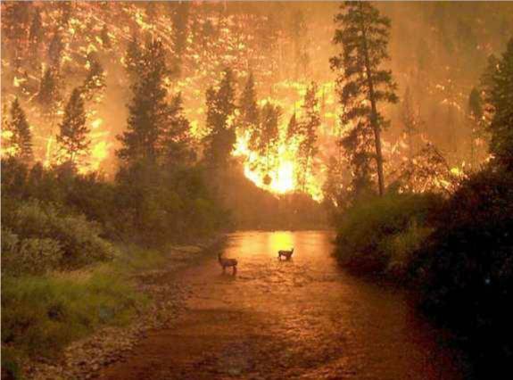
I recently stumbled across the above photograph, an image I remember well (not exactly fondly) from five-and-a-half years ago. It's a picture of the 2000 fires in the Bitterroot Valley, specifically the East Fork of the Bitterroot outside Conner, Montana. I was quite nearby at the time, in Salmon, Idaho, about an hour's drive south. It was the first time I was in the vicinity of major forest fires. I remember the smoke clouds to the west being so thick that we could look directly at the sun, sometimes seeing sunspots with our naked eyes through the perfect brown filter.

I've since floated and driven through several other small to medium fires. Though I was never in a scene as hellish as that photo, active blazes do put one in mind of scenes a few circles down in Inferno. The light is veiled and ruddy, the air unwholesome. Blackened silhouettes of trunks and stumps stand naked, carved into Rococo shapes by burning, some smoking like chimneys. Smoke pours from holes in the earth and stones tumble down the loosened slopes. Flames ripple up brushy hillsides or crackle into crowns of trees. I floated through one such on the Main Salmon in 2003 without incident. It seemed that we had come through after the worst was over, as the fire was calming down. But the next morning we awoke to strong winds, and looked back upstream to see an immense column of yellow-orange erupting into the sky above the canyon.

Whenever I have seen such fires in action, I have assumed the worst about what would be left when the flames were gone. But every time I have been pleasantly surprised. Where there's smoke there's fire, but there's usually vastly more smoke. The areas you see marked as burned in newspaper maps are very far from wastelands. Some patches are indeed devastated, but most areas are only mildly singed. Undergrowth soon flourishes happily, and wildflowers are profuse in the following years. Wildlife doesn't seem to mind burned zones particularly. I even spent time in the Kalmiopsis Wilderness in the years immediately following the Biscuit Fire, possibly the nastiest burn in living memory. Even there, there are still living trees, limpid water, bears, salmon, carnivorous plants. The most dramatic aftereffects (in Idaho, at least) are landslides. The rivers have run clear much more seldom than they did before the fire years, as any reasonably focused downpour induces the loosened mountainsides to cast themselves down in a wall of mud, logs and stones, often giving the rivers some wonderful new rapids in the process.

Cramer Creek Rapid (a.k.a. De-Rig) formed overnight from a debris flow in August 2003, shortly after the Cramer Fire, creating some of the biggest whitewater on the Salmon.

My point in all this is that forest fires most definitely do not destroy an area's value as wilderness. Nature's change and growth is often not a gentle process; there is violence and destruction in it. That is where much of the awe and majesty of wilderness is to be found, and it is what sets true wilderness apart from gentlemen's estates. The notion implicit in salvage logging of burned forests is that the area is ruined, so why not pull what resources we can from it? I don't mind the resource extraction per se. What I greatly mind is the attendant road-building in roadless areas, excused on the grounds of this alleged ruination, which is believable only to those who have no serious knowledge of the areas. Wilderness should be managed as wilderness, through fires, floods and everything else. I say again, these areas are far from ruined, even on the scale of a few years. Seeing them change, through slow growth or sudden shock, in ways one would never guess, is one of the great delights and privileges of knowing the wilderness.

This is sadly likely to be an issue in my neck of the woods in the coming year. New Mexico has had no significant snowfall this season; our 12,000-foot mountains show no white at all. There have already been fires in Colorado: it's freakin' January! For all I've said above, please don't think I enjoy seeing forests burn. I definitely don't want to see the entire Pecos Wilderness burn in a week. If we don't get some precipitation soon, things will be very grim. But they'll still be better than an infestation of new roads.